Tennessee Landforms -- arches and natural bridges| WGS84 |
| 35.356400 | -85.803200 |
| 35° 21.384'N | 85° 48.192'W |
| 35° 21' 23"N | 85° 48' 11.5"W |
| 16S 608737E 3913225N |
| convert to NAD27 |
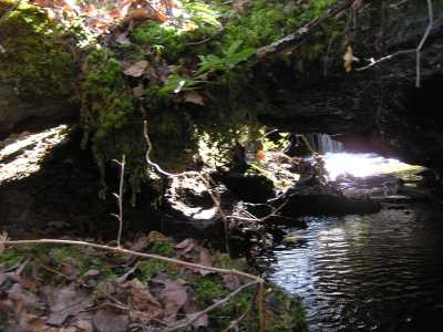
Nunley Hollow Bridge 5x4
Waypoint: GUA003 35.356400,-85.803200
County: Grundy landforms of Grundy county
Locale: private
NABSQNO 16S-608737-3913225
popup list of
nearby landforms (mileage, bearing)
MAPS
Select one of the following maps to display this waypoint (WGS84).
GPS
Remarks:
Reference: Larry Fogleman
small span, plus jeep road atop natural bridge and creek seeps
underneath
Tennessee landforms
home
arches
waterfalls
rocks
peaks
balds
sinks
lakes
regions
county
GSMNP landforms (TN/NC)
BSF landforms (TN/KY)
or nearby
lookout towers
Chuck Sutherland's www.tnlandforms.com the future (2024)
 ©
Tom Dunigan
©
Tom Dunigan