Tennessee Landforms -- waterfalls| WGS84 |
| 36.345000 | -83.512500 |
| 36° 20.7'N | 83° 30.75'W |
| 36° 20' 42"N | 83° 30' 45"W |
| 17S 274523E 4025146N |
| convert to NAD27 |
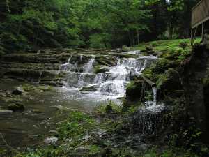
Puncheon Creek Middle Falls 25'
Waypoint: GRF004 36.345000,-83.512500
County: Grainger landforms of Grainger county
Locale: private
popup list of
nearby landforms (mileage, bearing)
MAPS
Select one of the following maps to display this waypoint (WGS84).
GPS
Remarks:
Reference: Robert Robbins
Tennessee landforms
home
arches
waterfalls
rocks
peaks
balds
sinks
lakes
regions
county
GSMNP landforms (TN/NC)
BSF landforms (TN/KY)
or nearby
lookout towers
Chuck Sutherland's www.tnlandforms.com the future (2024)
 ©
Tom Dunigan
©
Tom Dunigan