Tennessee Landforms -- waterfalls| WGS84 |
| 35.113780 | -85.879990 |
| 35° 6.827'N | 85° 52.799'W |
| 35° 6' 49.6"N | 85° 52' 47.9"W |
| 16S 602063E 3886235N |
| convert to NAD27 |
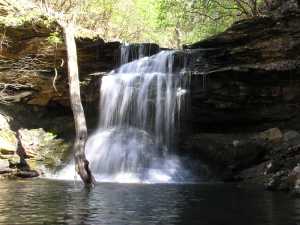
Tom Pack Falls 20'
Waypoint: FRF009 35.113780,-85.879990
County: Franklin landforms of Franklin county
Locale: state forest
popup list of
nearby landforms (mileage, bearing)
MAPS
Select one of the following maps to display this waypoint (WGS84).
GPS
Remarks:
Tennessee landforms
home
arches
waterfalls
rocks
peaks
balds
sinks
lakes
regions
county
GSMNP landforms (TN/NC)
BSF landforms (TN/KY)
or nearby
lookout towers
Chuck Sutherland's www.tnlandforms.com the future (2024)
 ©
Tom Dunigan
©
Tom Dunigan