Tennessee Landforms -- waterfalls| WGS84 |
| 35.203300 | -85.944100 |
| 35° 12.198'N | 85° 56.646'W |
| 35° 12' 11.9"N | 85° 56' 38.8"W |
| 16S 596116E 3896099N |
| convert to NAD27 |
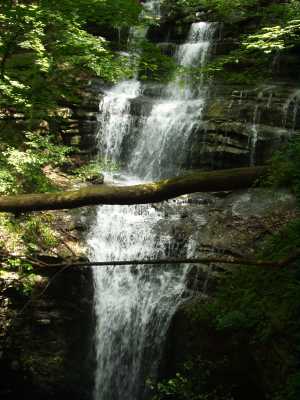
Bridal Veil Falls 50'
Waypoint: FRF001 35.203300,-85.944100
County: Franklin landforms of Franklin county
popup list of
nearby landforms (mileage, bearing)
MAPS
Select one of the following maps to display this waypoint (WGS84).
GPS
Remarks:
This falls starts in a spring and disappears into a sinkhole.
A small arch is located at the top of the sinkhole on the west side.
Tennessee landforms
home
arches
waterfalls
rocks
peaks
balds
sinks
lakes
regions
county
GSMNP landforms (TN/NC)
BSF landforms (TN/KY)
or nearby
lookout towers
Chuck Sutherland's www.tnlandforms.com the future (2024)
 ©
Tom Dunigan
©
Tom Dunigan