Tennessee Landforms -- arches and natural bridges| WGS84 |
| 35.203300 | -85.944100 |
| 35° 12.198'N | 85° 56.646'W |
| 35° 12' 11.9"N | 85° 56' 38.8"W |
| 16S 596116E 3896099N |
| convert to NAD27 |
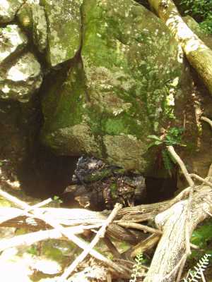
Bridal Veil Arch 6x18
Waypoint: FRA002 35.203300,-85.944100
County: Franklin landforms of Franklin county
NABSQNO 16S-596116-3896099
popup list of
nearby landforms (mileage, bearing)
MAPS
Select one of the following maps to display this waypoint (WGS84).
GPS
Remarks:
This arch is on the west side of the sink hole at the base of
Bridal Veil Falls.
Tennessee landforms
home
arches
waterfalls
rocks
peaks
balds
sinks
lakes
regions
county
GSMNP landforms (TN/NC)
BSF landforms (TN/KY)
or nearby
lookout towers
Chuck Sutherland's www.tnlandforms.com the future (2024)
 ©
Tom Dunigan
©
Tom Dunigan