Tennessee Landforms -- rock formations| WGS84 |
| 36.384200 | -85.036400 |
| 36° 23.052'N | 85° 2.184'W |
| 36° 23' 3.1"N | 85° 2' 11"W |
| 16S 676123E 4028354N |
| convert to NAD27 |
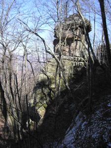
Skinner Mountain Chimney 40'
Waypoint: FER005 36.384200,-85.036400
County: Fentress landforms of Fentress county
popup list of
nearby landforms (mileage, bearing)
MAPS
Select one of the following maps to display this waypoint (WGS84).
GPS
Remarks:
Recently acquired Nature Conservancy
tract,
WMA
Tennessee landforms
home
arches
waterfalls
rocks
peaks
balds
sinks
lakes
regions
county
GSMNP landforms (TN/NC)
BSF landforms (TN/KY)
or nearby
lookout towers
Chuck Sutherland's www.tnlandforms.com the future (2024)
 ©
Tom Dunigan
©
Tom Dunigan