Tennessee Landforms -- waterfalls| WGS84 |
| 36.554600 | -84.860400 |
| 36° 33.276'N | 84° 51.624'W |
| 36° 33' 16.6"N | 84° 51' 37.4"W |
| 16S 691491E 4047595N |
| convert to NAD27 |
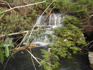
Williams Creek Falls 6'
Waypoint: FEF015 36.554600,-84.860400
County: Fentress landforms of Fentress county
Locale: PogueCreek
popup list of
nearby landforms (mileage, bearing)
MAPS
Select one of the following maps to display this waypoint (WGS84).
GPS
Remarks:
offtrail
Tennessee landforms
home
arches
waterfalls
rocks
peaks
balds
sinks
lakes
regions
county
GSMNP landforms (TN/NC)
BSF landforms (TN/KY)
or nearby
lookout towers
Chuck Sutherland's www.tnlandforms.com the future (2024)
 ©
Tom Dunigan
©
Tom Dunigan