Tennessee Landforms -- waterfalls| WGS84 |
| 36.527418 | -84.821108 |
| 36° 31.645'N | 84° 49.266'W |
| 36° 31' 38.7"N | 84° 49' 16"W |
| 16S 695076E 4044658N |
| convert to NAD27 |
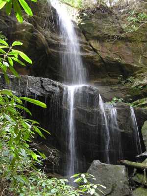
Pogue Creek Falls 40'
Waypoint: FEF013 36.527418,-84.821108
County: Fentress landforms of Fentress county
Locale: PogueCreek
popup list of
nearby landforms (mileage, bearing)
MAPS
Select one of the following maps to display this waypoint (WGS84).
GPS
Remarks:
wet-weather falls at headwaters of Pogue Creek.
off-trail, Pogue Creek Tract, recent Nature Conservancy
acquisition.
Also state
natural area and maps.
Byron Jorjorian photos
Tennessee landforms
home
arches
waterfalls
rocks
peaks
balds
sinks
lakes
regions
county
GSMNP landforms (TN/NC)
BSF landforms (TN/KY)
or nearby
lookout towers
Chuck Sutherland's www.tnlandforms.com the future (2024)
 ©
Tom Dunigan
©
Tom Dunigan