Tennessee Landforms -- waterfalls| WGS84 |
| 36.255789 | -85.040681 |
| 36° 15.347'N | 85° 2.441'W |
| 36° 15' 20.8"N | 85° 2' 26.5"W |
| 16S 676027E 4014100N |
| convert to NAD27 |
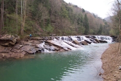
E. Fork Obey Falls 20'
Waypoint: FEF008 36.255789,-85.040681
County: Fentress landforms of Fentress county
Locale: private
popup list of
nearby landforms (mileage, bearing)
MAPS
Select one of the following maps to display this waypoint (WGS84).
GPS
Remarks:
Reference: Brad Neff
off-trail. River plunges off of Hartselle sandstone bedrock and
percolates into the Monteagle limestone.
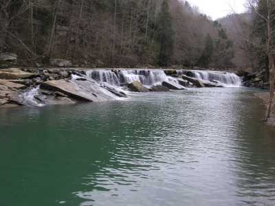
Following picture courtesy of Brad Neff
Tennessee landforms
home
arches
waterfalls
rocks
peaks
balds
sinks
lakes
regions
county
GSMNP landforms (TN/NC)
BSF landforms (TN/KY)
or nearby
lookout towers
Chuck Sutherland's www.tnlandforms.com the future (2024)
 ©
Tom Dunigan
©
Tom Dunigan