Tennessee Landforms -- arches and natural bridges| WGS84 |
| 36.303748 | -85.011177 |
| 36° 18.225'N | 85° 0.671'W |
| 36° 18' 13.5"N | 85° 0' 40.3"W |
| 16S 678569E 4019475N |
| convert to NAD27 |
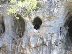
Z Hole 3x3
Waypoint: FEA055 36.303748,-85.011177
County: Fentress landforms of Fentress county
Locale: Obey
NABSQNO 16S-678569-4019475
popup list of
nearby landforms (mileage, bearing)
MAPS
Select one of the following maps to display this waypoint (WGS84).
GPS
Remarks:
 Also Sutherland's
photo
Also Sutherland's
photo
Tennessee landforms
home
arches
waterfalls
rocks
peaks
balds
sinks
lakes
regions
county
GSMNP landforms (TN/NC)
BSF landforms (TN/KY)
or nearby
lookout towers
Chuck Sutherland's www.tnlandforms.com the future (2024)
 ©
Tom Dunigan
©
Tom Dunigan