Tennessee Landforms -- arches and natural bridges| WGS84 |
| 36.524840 | -84.843200 |
| 36° 31.49'N | 84° 50.592'W |
| 36° 31' 29.4"N | 84° 50' 35.5"W |
| 16S 693104E 4044327N |
| convert to NAD27 |
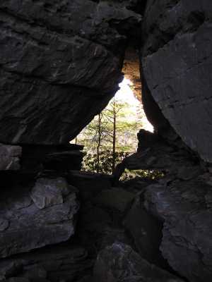
Needles Eye 16x20
Waypoint: FEA048 36.524840,-84.843200
County: Fentress landforms of Fentress county
Locale: PogueCreek
NABSQNO 16S-693104-4044327
popup list of
nearby landforms (mileage, bearing)
MAPS
Select one of the following maps to display this waypoint (WGS84).
GPS
Remarks:
Reference: Doyle Newburry
A high arch (actually breakdown between two massive caprocks) that
tunnels through the bluff high in the bluff wall.
Off-trail climb up two successive chutes from the west face.
Tennessee landforms
home
arches
waterfalls
rocks
peaks
balds
sinks
lakes
regions
county
GSMNP landforms (TN/NC)
BSF landforms (TN/KY)
or nearby
lookout towers
Chuck Sutherland's www.tnlandforms.com the future (2024)
 ©
Tom Dunigan
©
Tom Dunigan