Tennessee Landforms -- arches and natural bridges| WGS84 |
| 36.532900 | -84.801930 |
| 36° 31.974'N | 84° 48.116'W |
| 36° 31' 58.4"N | 84° 48' 7"W |
| 16S 696780E 4045305N |
| convert to NAD27 |
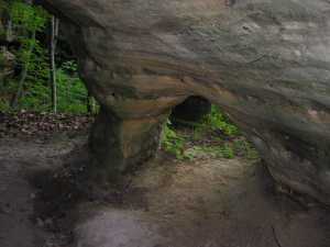
Watson Arch 2x3
Waypoint: FEA046 36.532900,-84.801930
County: Fentress landforms of Fentress county
Locale: forest
NABSQNO 16S-696780-4045305
popup list of
nearby landforms (mileage, bearing)
MAPS
Select one of the following maps to display this waypoint (WGS84).
GPS
Remarks:
Reference: Keith Garnes
Small column arch along new loop trail behind forestry maintenance
shed.
Tennessee landforms
home
arches
waterfalls
rocks
peaks
balds
sinks
lakes
regions
county
GSMNP landforms (TN/NC)
BSF landforms (TN/KY)
or nearby
lookout towers
Chuck Sutherland's www.tnlandforms.com the future (2024)
 ©
Tom Dunigan
©
Tom Dunigan