Tennessee Landforms -- arches and natural bridges| WGS84 |
| 36.379900 | -85.037300 |
| 36° 22.794'N | 85° 2.238'W |
| 36° 22' 47.6"N | 85° 2' 14.3"W |
| 16S 676051E 4027875N |
| convert to NAD27 |
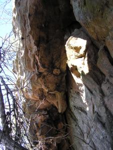
Skinner Mountain Arch 10x8
Waypoint: FEA044 36.379900,-85.037300
County: Fentress landforms of Fentress county
NABSQNO 16S-676051-4027875
popup list of
nearby landforms (mileage, bearing)
MAPS
Select one of the following maps to display this waypoint (WGS84).
GPS
Remarks:
Recently acquired Nature Conservancy
tract and
WMA
Tennessee landforms
home
arches
waterfalls
rocks
peaks
balds
sinks
lakes
regions
county
GSMNP landforms (TN/NC)
BSF landforms (TN/KY)
or nearby
lookout towers
Chuck Sutherland's www.tnlandforms.com the future (2024)
 ©
Tom Dunigan
©
Tom Dunigan