Tennessee Landforms -- arches and natural bridges| WGS84 |
| 36.528500 | -84.826000 |
| 36° 31.71'N | 84° 49.56'W |
| 36° 31' 42.6"N | 84° 49' 33.6"W |
| 16S 694636E 4044768N |
| convert to NAD27 |
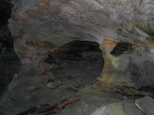
Keys Hole 4x4
Waypoint: FEA036 36.528500,-84.826000
County: Fentress landforms of Fentress county
Locale: PogueCreek
NABSQNO 16S-694636-4044768
popup list of
nearby landforms (mileage, bearing)
MAPS
Select one of the following maps to display this waypoint (WGS84).
GPS
Remarks:
Tennessee landforms
home
arches
waterfalls
rocks
peaks
balds
sinks
lakes
regions
county
GSMNP landforms (TN/NC)
BSF landforms (TN/KY)
or nearby
lookout towers
Chuck Sutherland's www.tnlandforms.com the future (2024)
 ©
Tom Dunigan
©
Tom Dunigan