Tennessee Landforms -- arches and natural bridges| WGS84 |
| 36.535200 | -84.825900 |
| 36° 32.112'N | 84° 49.554'W |
| 36° 32' 6.7"N | 84° 49' 33.2"W |
| 16S 694628E 4045511N |
| convert to NAD27 |
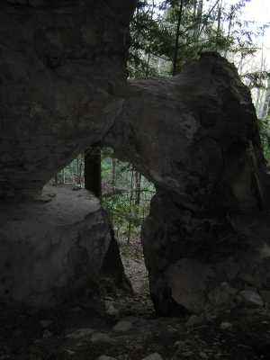
Chamber Arch 4x9
Waypoint: FEA027 36.535200,-84.825900
County: Fentress landforms of Fentress county
Locale: PogueCreek
NABSQNO 16S-694628-4045511
popup list of
nearby landforms (mileage, bearing)
MAPS
Select one of the following maps to display this waypoint (WGS84).
GPS
Remarks:
this column arch guards a chamber with
a small arch and a rock window. off-trail, Pogue Creek Tract, recent Nature Conservancy
acquisition.
Byron Jorjorian photos
Tennessee landforms
home
arches
waterfalls
rocks
peaks
balds
sinks
lakes
regions
county
GSMNP landforms (TN/NC)
BSF landforms (TN/KY)
or nearby
lookout towers
Chuck Sutherland's www.tnlandforms.com the future (2024)
 ©
Tom Dunigan
©
Tom Dunigan