Tennessee Landforms -- arches and natural bridges| WGS84 |
| 36.505000 | -84.761780 |
| 36° 30.3'N | 84° 45.707'W |
| 36° 30' 18"N | 84° 45' 42.4"W |
| 16S 700447E 4042292N |
| convert to NAD27 |
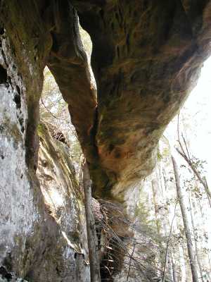
Oby's Double Arch 50x18
Waypoint: FEA014 36.505000,-84.761780
County: Fentress landforms of Fentress county
Locale: Big South Fork
NABSQNO 16S-700447-4042292
popup list of
nearby landforms (mileage, bearing)
MAPS
Select one of the following maps to display this waypoint (WGS84).
GPS
Remarks:
References: JNAD:TENN-7, WAD:44.14, '86 BSF map
Tennessee landforms
home
arches
waterfalls
rocks
peaks
balds
sinks
lakes
regions
county
GSMNP landforms (TN/NC)
BSF landforms (TN/KY)
or nearby
lookout towers
Chuck Sutherland's www.tnlandforms.com the future (2024)
 ©
Tom Dunigan
©
Tom Dunigan