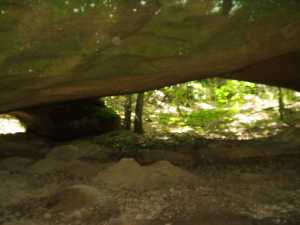
It's hard to get a picture of this large four legged arch. It also has a small skylight. A small arch can be found on the big bluff to the south, and York's Double Arch is 200' to the east.
| WGS84 | |
| 36.522060 | -84.869440 |
| 36° 31.324'N | 84° 52.166'W |
| 36° 31' 19.4"N | 84° 52' 10"W |
| 16S 690762E 4043966N | |
| convert to NAD27 | |
MAPS
Select one of the following maps to display this waypoint (WGS84).
GPS
Remarks:
References: JNAD:TENN-40, Bob Wheeley
It's hard to get a picture of this large four legged arch.
It also has a small skylight.
A small arch can be found on the big bluff to the south,
and
York's Double Arch is 200' to the east.