Tennessee Landforms -- arches and natural bridges| WGS84 |
| 36.522150 | -84.869300 |
| 36° 31.329'N | 84° 52.158'W |
| 36° 31' 19.7"N | 84° 52' 9.5"W |
| 16S 690774E 4043977N |
| convert to NAD27 |
York's Double Arch 30x12
Waypoint: FEA008 36.522150,-84.869300
County: Fentress landforms of Fentress county
Locale: PogueCreek
NABSQNO 16S-690774-4043977
popup list of
nearby landforms (mileage, bearing)
MAPS
Select one of the following maps to display this waypoint (WGS84).
GPS
Remarks:
References: JNAD:TENN-34, Bob Wheeley
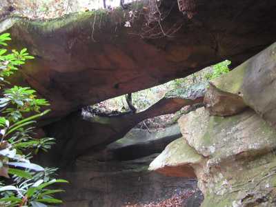
The four-legged York's Palace arch is about 200' to the west.
Tennessee landforms
home
arches
waterfalls
rocks
peaks
balds
sinks
lakes
regions
county
GSMNP landforms (TN/NC)
BSF landforms (TN/KY)
or nearby
lookout towers
Chuck Sutherland's www.tnlandforms.com the future (2024)
 ©
Tom Dunigan
©
Tom Dunigan