Tennessee Landforms -- arches and natural bridges| WGS84 |
| 36.449240 | -84.801050 |
| 36° 26.954'N | 84° 48.063'W |
| 36° 26' 57.2"N | 84° 48' 3.8"W |
| 16S 697070E 4036025N |
| convert to NAD27 |
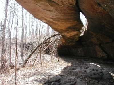
Fiddler's Arch 45x10
Waypoint: FEA003 36.449240,-84.801050
County: Fentress landforms of Fentress county
Locale: Big South Fork
NABSQNO 16S-697070-4036025
popup list of
nearby landforms (mileage, bearing)
MAPS
Select one of the following maps to display this waypoint (WGS84).
GPS
Remarks:
References: JNAD:TENN-35, WAD:44.13, Tom Des Jean
Tennessee landforms
home
arches
waterfalls
rocks
peaks
balds
sinks
lakes
regions
county
GSMNP landforms (TN/NC)
BSF landforms (TN/KY)
or nearby
lookout towers
Chuck Sutherland's www.tnlandforms.com the future (2024)
 ©
Tom Dunigan
©
Tom Dunigan