Tennessee Landforms -- waterfalls| WGS84 |
| 36.303259 | -86.920394 |
| 36° 18.196'N | 86° 55.224'W |
| 36° 18' 11.8"N | 86° 55' 13.4"W |
| 16S 507147E 4017588N |
| convert to NAD27 |
Marrowbone Falls
Waypoint: DAF002 36.303259,-86.920394
County: Davidson landforms of Davidson county
popup list of
nearby landforms (mileage, bearing)
MAPS
Select one of the following maps to display this waypoint (WGS84).
GPS
Remarks:
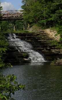 Tim McKinley's photo
Tennessee landforms
home
arches
waterfalls
rocks
peaks
balds
sinks
lakes
regions
county
GSMNP landforms (TN/NC)
BSF landforms (TN/KY)
or nearby
lookout towers
Chuck Sutherland's www.tnlandforms.com the future (2024)
 ©
Tom Dunigan
©
Tom Dunigan