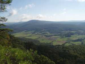
 View from the
Cumberland Trail.
| WGS84 | |
| 35.840400 | -84.918500 |
| 35° 50.424'N | 84° 55.11'W |
| 35° 50' 25.4"N | 84° 55' 6.6"W |
| 16S 687991E 3968247N | |
| convert to NAD27 | |
MAPS
Select one of the following maps to display this waypoint (WGS84).
GPS
Remarks:
A National Natural Landmark, one of the larger sinkholes in the US -- 5 square miles. See wikipedia or more info
 View from the
Cumberland Trail.
From the digital analysis of TN sinkholes 2013 10m DEM
weighted centroid: 35.83742333930,-84.9277519418
Area: 13.6 km2
Perimeter: 38.9 km, boundary
Depth: 42.7 m
Volume: 37736946 m3
Low: 1533.3' at 35.856018,-84.927129
High: 1664.7' at 35.82663,-84.90166 spill point
An interior path is nearly 5 miles long.
The waters in Grassy Cove exit through Mill Cave and resurge at Head of Sequatchie Spring in Devilstep Hollow (35.792854,-85.007616) at an elevation of 1075'. Near Cave Spring (35.795917,-85.008431) is a 50' sinkhole.
In 2017, Chuck Sutherland re-analyzed Grassy Cave with TN LiDAR elevation data:
Watershed Area 33.1770 Kilometers2
Watershed Perimeter 42.1524 Kilometers
Sinkhole Area 13.3112 Kilometers2
Sinkhole Perimeter 35.719226 Kilometers
Sinkhole Volume 999,360,713 Meters3
Sinkhole Major Axis 7.673683 Kilometers
Sinkhole Minor Axis 4.362937 Kilometers
Sinkhole Declination 30.8 Degrees
Sinkhole Minimum Elevation 467.27 MASL
Sinkhole Maximum Elevation 507.24 MASL
Sinkhole Depth 39.97 Meters