Tennessee Landforms -- arches and natural bridges| WGS84 |
| 36.071040 | -84.983020 |
| 36° 4.262'N | 84° 58.981'W |
| 36° 4' 15.7"N | 84° 58' 58.9"W |
| 16S 681634E 3993711N |
| convert to NAD27 |
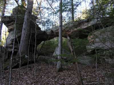
Cindy Creek Arch 28x9
Waypoint: CUA004 36.071040,-84.983020
County: Cumberland landforms of Cumberland county
Locale: private
NABSQNO 16S-681634-3993711
popup list of
nearby landforms (mileage, bearing)
MAPS
Select one of the following maps to display this waypoint (WGS84).
GPS
Remarks:
Reference and photo: TAS
Tennessee landforms
home
arches
waterfalls
rocks
peaks
balds
sinks
lakes
regions
county
GSMNP landforms (TN/NC)
BSF landforms (TN/KY)
or nearby
lookout towers
Chuck Sutherland's www.tnlandforms.com the future (2024)
 ©
Tom Dunigan
©
Tom Dunigan