Tennessee Landforms -- waterfalls| WGS84 |
| 36.220280 | -82.051610 |
| 36° 13.217'N | 82° 3.097'W |
| 36° 13' 13"N | 82° 3' 5.8"W |
| 17S 405484E 4008894N |
| convert to NAD27 |
Hardcore Cascades 20'
Waypoint: CTF018 36.220280,-82.051610
County: Carter landforms of Carter county
Locale: Cherokee National Forest
popup list of
nearby landforms (mileage, bearing)
MAPS
Select one of the following maps to display this waypoint (WGS84).
GPS
Remarks:
Reference and photo: Benjamin Trotter
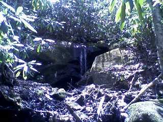 Along the AT, just add water.
Tennessee landforms
home
arches
waterfalls
rocks
peaks
balds
sinks
lakes
regions
county
GSMNP landforms (TN/NC)
BSF landforms (TN/KY)
or nearby
lookout towers
Chuck Sutherland's www.tnlandforms.com the future (2024)
 ©
Tom Dunigan
©
Tom Dunigan