Tennessee Landforms -- waterfalls| WGS84 |
| 36.219300 | -81.985000 |
| 36° 13.158'N | 81° 59.1'W |
| 36° 13' 9.5"N | 81° 59' 6"W |
| 17S 411469E 4008722N |
| convert to NAD27 |
Mountaineer Falls 20'
Waypoint: CTF014 36.219300,-81.985000
County: Carter landforms of Carter county
Locale: Cherokee National Forest
popup list of
nearby landforms (mileage, bearing)
MAPS
Select one of the following maps to display this waypoint (WGS84).
GPS
Remarks:
along a
new section of the AT.
Here are some pics
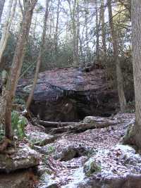
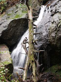 Photo by Gregory Plumb, Author of
Waterfalls of Tennessee
Photo by Gregory Plumb, Author of
Waterfalls of Tennessee
Tennessee landforms
home
arches
waterfalls
rocks
peaks
balds
sinks
lakes
regions
county
GSMNP landforms (TN/NC)
BSF landforms (TN/KY)
or nearby
lookout towers
Chuck Sutherland's www.tnlandforms.com the future (2024)
 ©
Tom Dunigan
©
Tom Dunigan