Tennessee Landforms -- waterfalls| WGS84 |
| 36.210210 | -81.973950 |
| 36° 12.613'N | 81° 58.437'W |
| 36° 12' 36.8"N | 81° 58' 26.2"W |
| 17S 412452E 4007704N |
| convert to NAD27 |
Splash Dam Falls 25'
Waypoint: CTF013 36.210210,-81.973950
County: Carter landforms of Carter county
Locale: Cherokee National Forest
popup list of
nearby landforms (mileage, bearing)
MAPS
Select one of the following maps to display this waypoint (WGS84).
GPS
Remarks:
Now not for from the re-routed Appalachian Trail.
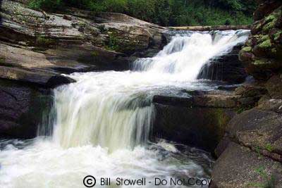 Photo courtesy of Bill Stowell.
Tennessee landforms
home
arches
waterfalls
rocks
peaks
balds
sinks
lakes
regions
county
GSMNP landforms (TN/NC)
BSF landforms (TN/KY)
or nearby
lookout towers
Chuck Sutherland's www.tnlandforms.com the future (2024)
 ©
Tom Dunigan
©
Tom Dunigan