Tennessee Landforms -- waterfalls| WGS84 |
| 36.202780 | -81.982500 |
| 36° 12.167'N | 81° 58.95'W |
| 36° 12' 10"N | 81° 58' 57"W |
| 17S 411676E 4006887N |
| convert to NAD27 |
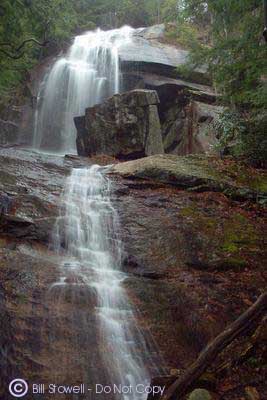
Jones Falls 100'
Waypoint: CTF006 36.202780,-81.982500
County: Carter landforms of Carter county
Locale: Cherokee National Forest
popup list of
nearby landforms (mileage, bearing)
MAPS
Select one of the following maps to display this waypoint (WGS84).
GPS
Remarks:
along a
new section of the AT.
Photo courtesy of Bill Stowell.
Stephen Kasten reports a 20' Upper Jones Falls about 0.1 miles above Jones Falls, map
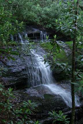 Photo courtesy of Steve Kasten
Tennessee landforms
home
arches
waterfalls
rocks
peaks
balds
sinks
lakes
regions
county
GSMNP landforms (TN/NC)
BSF landforms (TN/KY)
or nearby
lookout towers
Chuck Sutherland's www.tnlandforms.com the future (2024)
 ©
Tom Dunigan
©
Tom Dunigan