Tennessee Landforms -- waterfalls| WGS84 |
| 35.822200 | -83.178560 |
| 35° 49.332'N | 83° 10.714'W |
| 35° 49' 19.9"N | 83° 10' 42.8"W |
| 17S 303197E 3966419N |
| convert to NAD27 |
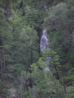
Buzzard Roost Falls 130'
Waypoint: COF004 35.822200,-83.178560
County: Cocke landforms of Cocke county
Locale: Cherokee National Forest
popup list of
nearby landforms (mileage, bearing)
MAPS
Select one of the following maps to display this waypoint (WGS84).
GPS
Remarks:
wet-weather falls from I-40 mile 444.5
Tennessee landforms
home
arches
waterfalls
rocks
peaks
balds
sinks
lakes
regions
county
GSMNP landforms (TN/NC)
BSF landforms (TN/KY)
or nearby
lookout towers
Chuck Sutherland's www.tnlandforms.com the future (2024)
 ©
Tom Dunigan
©
Tom Dunigan