Tennessee Landforms -- waterfalls| WGS84 |
| 35.428677 | -86.180918 |
| 35° 25.721'N | 86° 10.855'W |
| 35° 25' 43.3"N | 86° 10' 51.3"W |
| 16S 574352E 3920891N |
| convert to NAD27 |
Timber Falls 40'
Waypoint: CFF018 35.428677,-86.180918
County: Coffee landforms of Coffee county
popup list of
nearby landforms (mileage, bearing)
MAPS
Select one of the following maps to display this waypoint (WGS84).
GPS
Remarks:
Reference and photo: Meredith Odell
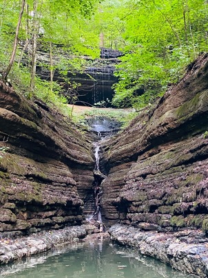 wet-weather falls
Tennessee landforms
home
arches
waterfalls
rocks
peaks
balds
sinks
lakes
regions
county
GSMNP landforms (TN/NC)
BSF landforms (TN/KY)
or nearby
lookout towers
Chuck Sutherland's www.tnlandforms.com the future (2024)
 ©
Tom Dunigan
©
Tom Dunigan