Tennessee Landforms -- waterfalls| WGS84 |
| 36.436270 | -84.068500 |
| 36° 26.176'N | 84° 4.11'W |
| 36° 26' 10.6"N | 84° 4' 6.6"W |
| 16S 762780E 4036334N |
| convert to NAD27 |
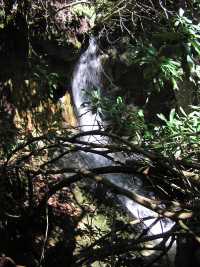
Pond Falls(2) 20'
Waypoint: CAF022 36.436270,-84.068500
County: Campbell landforms of Campbell county
Locale: private
popup list of
nearby landforms (mileage, bearing)
MAPS
Select one of the following maps to display this waypoint (WGS84).
GPS
Remarks:
A 20' falls downstream from the pond. Also a wet-weather
feeder falls (40') downstream.
McCloud Mountain
Tennessee landforms
home
arches
waterfalls
rocks
peaks
balds
sinks
lakes
regions
county
GSMNP landforms (TN/NC)
BSF landforms (TN/KY)
or nearby
lookout towers
Chuck Sutherland's www.tnlandforms.com the future (2024)
 ©
Tom Dunigan
©
Tom Dunigan