Tennessee Landforms -- waterfalls| WGS84 |
| 36.319500 | -84.251300 |
| 36° 19.17'N | 84° 15.078'W |
| 36° 19' 10.2"N | 84° 15' 4.7"W |
| 16S 746759E 4022894N |
| convert to NAD27 |
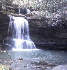
Asher Branch Falls 18'
Waypoint: CAF015 36.319500,-84.251300
County: Campbell landforms of Campbell county
Locale: RoyalBlue
popup list of
nearby landforms (mileage, bearing)
MAPS
Select one of the following maps to display this waypoint (WGS84).
GPS
Remarks:
Reference: Kevin Baker
Tennessee landforms
home
arches
waterfalls
rocks
peaks
balds
sinks
lakes
regions
county
GSMNP landforms (TN/NC)
BSF landforms (TN/KY)
or nearby
lookout towers
Chuck Sutherland's www.tnlandforms.com the future (2024)
 ©
Tom Dunigan
©
Tom Dunigan