Tennessee Landforms -- waterfalls| WGS84 |
| 36.304300 | -84.256700 |
| 36° 18.258'N | 84° 15.402'W |
| 36° 18' 15.5"N | 84° 15' 24.1"W |
| 16S 746322E 4021194N |
| convert to NAD27 |
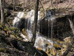
Duncan Branch Falls(u) 20'
Waypoint: CAF009 36.304300,-84.256700
County: Campbell landforms of Campbell county
Locale: Cumberland Trail
popup list of
nearby landforms (mileage, bearing)
MAPS
Select one of the following maps to display this waypoint (WGS84).
GPS
Remarks:
Along Cumberland Trail
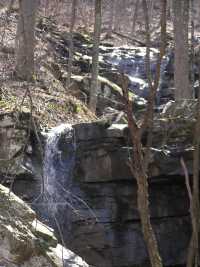 The south fork has steep wet-weather cascade, off trail at
36.3023 -84.2554
The south fork has steep wet-weather cascade, off trail at
36.3023 -84.2554
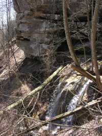 This falls is the last drop of a long wet-weather
cascde a Overhang Rock. (
36.3025 -84.26188)
This falls is the last drop of a long wet-weather
cascde a Overhang Rock. (
36.3025 -84.26188)
Tennessee landforms
home
arches
waterfalls
rocks
peaks
balds
sinks
lakes
regions
county
GSMNP landforms (TN/NC)
BSF landforms (TN/KY)
or nearby
lookout towers
Chuck Sutherland's www.tnlandforms.com the future (2024)
 ©
Tom Dunigan
©
Tom Dunigan