Tennessee Landforms -- waterfalls| WGS84 |
| 36.327000 | -84.225400 |
| 36° 19.62'N | 84° 13.524'W |
| 36° 19' 37.2"N | 84° 13' 31.4"W |
| 16S 749061E 4023793N |
| convert to NAD27 |
Bruce Cr Falls (l) 12'
Waypoint: CAF006 36.327000,-84.225400
County: Campbell landforms of Campbell county
Locale: Cumberland Trail
popup list of
nearby landforms (mileage, bearing)
MAPS
Select one of the following maps to display this waypoint (WGS84).
GPS
Remarks:
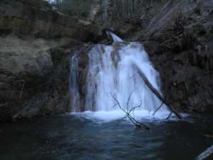 lower falls, upstream are
main falls
lower falls, upstream are
main falls
Tennessee landforms
home
arches
waterfalls
rocks
peaks
balds
sinks
lakes
regions
county
GSMNP landforms (TN/NC)
BSF landforms (TN/KY)
or nearby
lookout towers
Chuck Sutherland's www.tnlandforms.com the future (2024)
 ©
Tom Dunigan
©
Tom Dunigan