Tennessee Landforms -- arches and natural bridges| WGS84 |
| 36.464550 | -84.018550 |
| 36° 27.873'N | 84° 1.113'W |
| 36° 27' 52.4"N | 84° 1' 6.8"W |
| 16S 767162E 4039609N |
| convert to NAD27 |
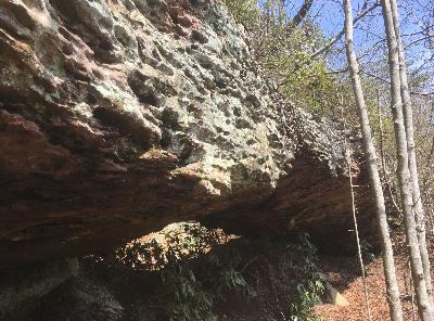
Yancey Arch 20x5
Waypoint: CAA017 36.464550,-84.018550
County: Campbell landforms of Campbell county
NABSQNO 16S-767162-4039609
popup list of
nearby landforms (mileage, bearing)
MAPS
Select one of the following maps to display this waypoint (WGS84).
GPS
Remarks:
Reference and photo: Seth Yancey
 location approximate, or 36.464649,-84.018763
Tennessee landforms
home
arches
waterfalls
rocks
peaks
balds
sinks
lakes
regions
county
GSMNP landforms (TN/NC)
BSF landforms (TN/KY)
or nearby
lookout towers
Chuck Sutherland's www.tnlandforms.com the future (2024)
 ©
Tom Dunigan
©
Tom Dunigan