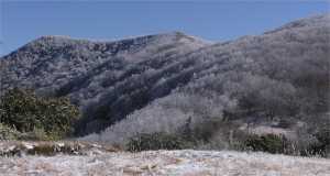
Tennessee Landforms -- rock formations| WGS84 |
| 35.564096 | -83.714027 |
| 35° 33.846'N | 83° 42.842'W |
| 35° 33' 50.8"N | 83° 42' 50.5"W |
| 17S 254022E 3938992N |
| convert to NAD27 |
Rocky Top
Waypoint: BTR001 35.564096,-83.714027
County: Blount landforms of Blount county
Locale: Great Smoky Mountains National Park
popup list of
nearby landforms (mileage, bearing)
MAPS
Select one of the following maps to display this waypoint (WGS84).
GPS
Remarks:
Rocky Top Tennessee ... sing along with UT band!
The waypoint is for the Rocky Top (5441') designated on USGS topo, some suggest
it is the next peak at 5485'.

Tennessee landforms
home
arches
waterfalls
rocks
peaks
balds
sinks
lakes
regions
county
GSMNP landforms (TN/NC)
BSF landforms (TN/KY)
or nearby
lookout towers
Chuck Sutherland's www.tnlandforms.com the future (2024)
 ©
Tom Dunigan

