Tennessee Landforms -- waterfalls| WGS84 |
| 35.638590 | -83.689770 |
| 35° 38.315'N | 83° 41.386'W |
| 35° 38' 18.9"N | 83° 41' 23.2"W |
| 17S 256447E 3947196N |
| convert to NAD27 |
Walker Fields Cascade 40'
Waypoint: BTF034 35.638590,-83.689770
County: Blount landforms of Blount county
Locale: Great Smoky Mountains National Park
popup list of
nearby landforms (mileage, bearing)
MAPS
Select one of the following maps to display this waypoint (WGS84).
GPS
Remarks:
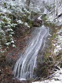 wet-weather cascade
Tennessee landforms
home
arches
waterfalls
rocks
peaks
balds
sinks
lakes
regions
county
GSMNP landforms (TN/NC)
BSF landforms (TN/KY)
or nearby
lookout towers
Chuck Sutherland's www.tnlandforms.com the future (2024)
 ©
Tom Dunigan
©
Tom Dunigan