Tennessee Landforms -- waterfalls| WGS84 |
| 35.710790 | -83.776570 |
| 35° 42.647'N | 83° 46.594'W |
| 35° 42' 38.8"N | 83° 46' 35.6"W |
| 17S 248812E 3955426N |
| convert to NAD27 |
Wesley Woods Falls 35'
Waypoint: BTF029 35.710790,-83.776570
County: Blount landforms of Blount county
Locale: private
popup list of
nearby landforms (mileage, bearing)
MAPS
Select one of the following maps to display this waypoint (WGS84).
GPS
Remarks:
Reference: Byron Hartzler
private, Camp Wesley Woods
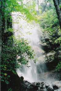 photo courtesy of Bob Hayes
Sharon Blackstock photo
Tennessee landforms
home
arches
waterfalls
rocks
peaks
balds
sinks
lakes
regions
county
GSMNP landforms (TN/NC)
BSF landforms (TN/KY)
or nearby
lookout towers
Chuck Sutherland's www.tnlandforms.com the future (2024)
 ©
Tom Dunigan
©
Tom Dunigan