| WGS84 | |
| 35.555660 | -83.982540 |
| 35° 33.34'N | 83° 58.952'W |
| 35° 33' 20.4"N | 83° 58' 57.1"W |
| 17S 229651E 3938760N | |
| convert to NAD27 | |
MAPS
Select one of the following maps to display this waypoint (WGS84).
GPS
Remarks:
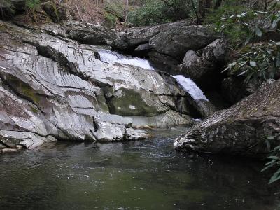
A 25' cascade is located about 1 mile upstream on Panther Creek, off-trail. See Garner 1900 black & white photo (Nine Mile Creek?) Unless you're in a boat, you'll need to bushwhack over the ridge to get to Panther Creek. All off-trail along remnants of old roadbed (logging & slate mining), see 1931 Park map Also Anchor Arch and Panther Creek Falls are further upstream.