Tennessee Landforms -- waterfalls| WGS84 |
| 35.528600 | -83.977400 |
| 35° 31.716'N | 83° 58.644'W |
| 35° 31' 43"N | 83° 58' 38.6"W |
| 17S 230026E 3935744N |
| convert to NAD27 |
Shop Creek Falls 12'
Waypoint: BTF026 35.528600,-83.977400
County: Blount landforms of Blount county
Locale: Great Smoky Mountains National Park
popup list of
nearby landforms (mileage, bearing)
MAPS
Select one of the following maps to display this waypoint (WGS84).
GPS
Remarks:
wet-weather falls. off-trail.
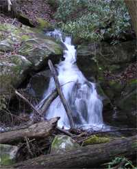
1931 topo shows old road bed along Shop Creek.
About a half mile upstream of the falls is the naked
Lady of Shop Creek
Tennessee landforms
home
arches
waterfalls
rocks
peaks
balds
sinks
lakes
regions
county
GSMNP landforms (TN/NC)
BSF landforms (TN/KY)
or nearby
lookout towers
Chuck Sutherland's www.tnlandforms.com the future (2024)
 ©
Tom Dunigan
©
Tom Dunigan