Tennessee Landforms -- waterfalls| WGS84 |
| 35.610940 | -83.779992 |
| 35° 36.656'N | 83° 46.8'W |
| 35° 36' 39.4"N | 83° 46' 48"W |
| 17S 248189E 3944356N |
| convert to NAD27 |
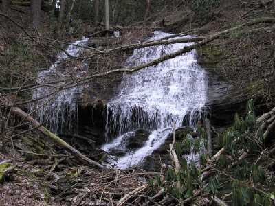
Crooked Arm Falls 25'
Waypoint: BTF004 35.610940,-83.779992
County: Blount landforms of Blount county
Locale: Great Smoky Mountains National Park
popup list of
nearby landforms (mileage, bearing)
MAPS
Select one of the following maps to display this waypoint (WGS84).
GPS
Remarks:
Tennessee landforms
home
arches
waterfalls
rocks
peaks
balds
sinks
lakes
regions
county
GSMNP landforms (TN/NC)
BSF landforms (TN/KY)
or nearby
lookout towers
Chuck Sutherland's www.tnlandforms.com the future (2024)
 ©
Tom Dunigan
©
Tom Dunigan