Tennessee Landforms -- arches and natural bridges| WGS84 |
| 35.476760 | -83.951900 |
| 35° 28.606'N | 83° 57.114'W |
| 35° 28' 36.4"N | 83° 57' 6.8"W |
| 17S 232167E 3929922N |
| convert to NAD27 |
Calderwood Tunnel
Waypoint: BTA004 35.476760,-83.951900
County: Blount landforms of Blount county
Locale: Calderwood
NABSQNO 17S-232167-3929922
popup list of
nearby landforms (mileage, bearing)
MAPS
Select one of the following maps to display this waypoint (WGS84).
GPS
Remarks:
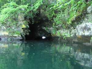
A submerged (if lake is above 964') 1914 railroad tunnel, bout 50' long.
See Tapoco history
and TVA
Calderwood Dam release & lake levels,
occasionally the lake is dropped 4 to 7', but can rise rapidly.
Tennessee landforms
home
arches
waterfalls
rocks
peaks
balds
sinks
lakes
regions
county
GSMNP landforms (TN/NC)
BSF landforms (TN/KY)
or nearby
lookout towers
Chuck Sutherland's www.tnlandforms.com the future (2024)
 ©
Tom Dunigan
©
Tom Dunigan