Tennessee Landforms -- arches and natural bridges| WGS84 |
| 35.562600 | -83.974500 |
| 35° 33.756'N | 83° 58.47'W |
| 35° 33' 45.4"N | 83° 58' 28.2"W |
| 17S 230403E 3939508N |
| convert to NAD27 |
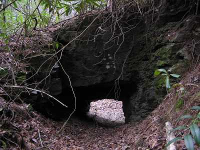
Anchor Arch 4x3
Waypoint: BTA003 35.562600,-83.974500
County: Blount landforms of Blount county
Locale: Great Smoky Mountains National Park
NABSQNO 17S-230403-3939508
popup list of
nearby landforms (mileage, bearing)
MAPS
Select one of the following maps to display this waypoint (WGS84).
GPS
Remarks:
Small (man-made?) arch on edge of Panther Creek. Old cables indicate that it
was used as an anchor point in years past. off-trail,
remnants of old roadbed (logging & slate mining), see
1931 Park map
Further upstream is Panther Creek falls
Tennessee landforms
home
arches
waterfalls
rocks
peaks
balds
sinks
lakes
regions
county
GSMNP landforms (TN/NC)
BSF landforms (TN/KY)
or nearby
lookout towers
Chuck Sutherland's www.tnlandforms.com the future (2024)
 ©
Tom Dunigan
©
Tom Dunigan