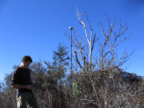
The Great Smoky Mountains National Park is conducting a GPS elevation survey of the park's peaks. Under the direction of Park GIS specialist, Tom Colson, volunteers are toting the GPS with its antenna bipod into the high country and spending four to five hours with the unit as it acquires GPS data. With post-processing (and an unobstructed view of the sky), the survey is providing location and elevation data accurate to 5 cm. See call for volunteers and Yahoo group (members only) Some survey trip reports: West Point | Big Butt | Rich Mtn
Here are some unofficial preliminary results.
| Peak | GSMNP LiDAR | GPS survey | USGS/NC LiDAR |
| Balsam Corner | 6041.76' | TBD | 6041.9' (3m) 35.671235,-83.181860 |
| Big Butt | 6030.22' | 6032.75' (12/3/11) 35.671672,-83.170069 error 0.147m precise |
6030.4' (3m) 35.671698,-83.17010 |
| Big Cataloochee | 6152.20' | TBD | 6152.34' (BE) 35.67191 -83.17588 SE 6155' |
| Cliff Top | 6557.9' (1.5m) 35.654297,-83.444209 |
6554.91' (11/5/11) 35.654466,-83.444324 error: 0.034 m precise |
6573.0' (10m) 35.653935,-83.443843 BM 6555' |
| Clingmans Dome | 6645.3' (1.5m) 35.562919,-83.498540 |
TBD | 6644.28' (BE) 35.56286,-83.49860 BM 6643' |
| Luftee Knob | 6184.03' | TBD | 6215.91' (BE) 35.692559,-83.215058 SE 6234 |
| Marks Knob | 6156.55' | TBD | 6163.2' (3m) 35.680093,-83.248434 SE 6169 |
| Mount Ambler | 6121.0' (1.5m) 35.624617,-83.393054 |
TBD | 6117.12' (BE) 35.624744,-83.393026 |
| Mount Buckley | 6576.0' (1.5m) 35.562185,-83.506050 |
6575.60' (11/20/11) 35.562238,-83.506004 error: 0.055m precise |
6574.48' (3m) 35.562221,-83.505926 |
| Mount Chapman | 6431.9' (1.5m) 35.686738,-83.270981 |
TBD | 6426.21' (3m) 35.686705,-83.271053 SE 6417' |
| Mount Collins | 6191.5' (1.5m) 35.586515,-83.472490 |
6196.36' (11/19/11) 35.586555,-83.472446 error: 19.27m precise |
6190.43' (3m) 35.586523,-83.472534 BM 6188 |
| Mount Guyot | 6625.3' (1.5m) 35.705297,-83.257356 |
TBD | 6621.83' (BE) 35.705211,-83.257471 BM 6621' |
| Mount Hardison | 6144.58' | 6149.99 (1/29/12) 35.688447,-83.249203 error: 0.096m precise |
6148.3' (3m) 35.688426,-83.249205 BM 6134' |
| Mount Kephart | 6218.8' (1.5m) 35.630896,-83.389792 |
6218.48 (3/20/12) 35.630912 -83.389746 error: 0.046m precise |
6218.17' (BE) 35.63089,-83.38979 SE 6217' |
| Mount LeConte | 6594.5' (1.5m) 35.654167,-83.436581 |
TBD | 6574.7' (10m) 35.654306,-83.436713 SE 6593' |
| Mount Love | 6416.6' (1.5m) 35.566811,-83.493562 |
6416.82' (11/25/11) 35.566886 -83.493302 error: 0.086m precise |
6416.39' (BE) 35.566861,-83.493355 |
| Mount Sequoyah | 6009.7' (1.5m) 35.675461,-83.282590 |
TBD | 6009.2' (BE) 35.67544,-83.28257 BM 6003 N |
| Mount Yonaguska | 6164.29' | TBD | 6178.1' (3m) 35.694136,-83.248279 |
| Myrtle Point | 6534.65' | TBD | (10m) |
| Old Black | 6361.3' (1.5m) 35.715106,-83.255253 |
TBD | 6370.5' (10m) 35.715046,-83.255324 SE 6370 |
| Thermo Knob | 6076.30' | TBD | 6090.4' (3m) 35.693611,-83.224144 |
| Thermo Knob W | 6076.30' | TBD | 6117.2' (3m) 35.694013,-83.225872 |
| Tricorner Knob | 6149.9' (1.5m) 35.695722,-83.254352 |
TBD | 6144.9' (3m) 35.695679,-83.254452 |
| West Point | 6354.6' (1.5m) 35.654655,-83.453254 |
6356.08' (12/2/11) 35.654663,-83.453209 error: 0.038m precise |
6338.5' (10m) 35.654583,-83.453009 SE 6344' |
| Rich Mountain | 3695.0' (1.5m) 35.628689,-83.785096 |
3699.11' (12/14/11) 35.628705,-83.785100 error: 1.228m precise |
3688.6' (10m) 35.628657,-83.785046 NGS 3701' |
| Gregory Bald | 4951.1' (1.5m) 35.520666,-83.865380 |
TBD | 4948.48' (BE) 35.520713,-83.865315 BM 4949 |
| Thunderhead Mtn | 5530.3' (1.5m) 35.568539,-83.706315 |
TBD | 5524.75' (BE) 35.568617,-83.706220 BM 5527 |
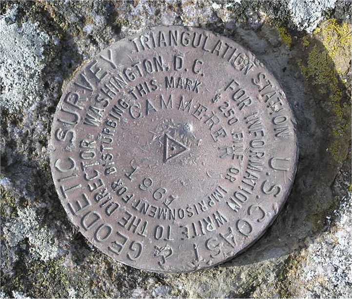
| Mount Cammerer | 4918.3' (1.5m) 35.763276,-83.161794 |
TBD | 4908.1 (10m) 35.763276,-83.161794 NGS 4916 |
Measuring the elevation of a mountain peak is tricky no matter the technology. In the forested summits of the east, it is difficult for LiDAR aerial scans to get bare-earth returns (see Big Cataloochee bare earth LiDAR). GPS ground surveys may not have a clear view of the sky. Any ground survey is faced with actually determining where the highest bump is on some of the "rounded" peaks (Big Cataloochee, Mount Sequoyah). Often USGS survey markers are seated in nearby rocks and are not at the "high point" (see further discussion on USGS surveys). And finally, error is sometimes introduced by the human element, see discussion on the phantom peak of Big Cataloochee.
More info