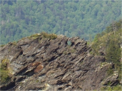
South window and north window.
| WGS84 | |
| 35.635900 | -83.445800 |
| 35° 38.154'N | 83° 26.748'W |
| 35° 38' 9.2"N | 83° 26' 44.9"W |
| 17S 278535E 3946321N | |
| convert to NAD27 | |
MAPS
Select one of the following maps to display this waypoint (WGS84).
GPS
Remarks:
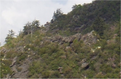
Two small windows are visible on the top of a craggy ridge line (Little Duck Hawk Ridge) 1000' to the west of the Alum Cave Trail. The windows are best viewed as the trail climbs N toward Alum Cave. Peregrine falcons are often seen along the ridge line. The waypoint is for the northern most window. The second window is at 35.6352 N 83.4456 W, 250' south.
South window and north window.
Dutch Roth's 1935 picture or another and Sutherland's photo
 AT shelters
BSF landforms (TN/KY)
AT shelters
BSF landforms (TN/KY)