Great Smoky Mountains National Park Campsites| WGS84 |
| 35.561842 | -83.732747 |
| 35° 33.711'N | 83° 43.965'W |
| 35° 33' 42.7"N | 83° 43' 57.9"W |
| 17S 252318E 3938789N |
| convert to NAD27 |
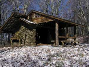
SHELTER SPENCE FIELD 
Waypoint: SHSPFL 35.561842,-83.732747
Locale: AT AT
Elevation: 4900'
reservation and fee required
GSMNP camping info permits, fees, reservations etc.
popup list of
nearby landforms/campsites (mileage, bearing)
MAPS
Select one of the following maps to display this waypoint (WGS84).
GPS
Remarks:
Reservation required: max 12 people, 12 horses
See additional AT shelter info.
see Dutch Roth's
1946 photo
and
1941 photo
GSMNP landforms and campsites
and
trails (TN/NC)
 AT shelters
BSF landforms (TN/KY)
AT shelters
BSF landforms (TN/KY)
Tennessee landforms
home
arches
waterfalls
rocks
peaks
balds
sinkholes
lakes
regions
 ©
Tom Dunigan
©
Tom Dunigan