Great Smoky Mountains National Park Campsites| WGS84 |
| 35.564281 | -83.568298 |
| 35° 33.857'N | 83° 34.098'W |
| 35° 33' 51.4"N | 83° 34' 5.9"W |
| 17S 267233E 3938658N |
| convert to NAD27 |
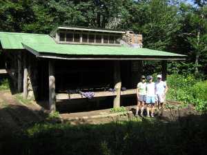
SHELTER SILERS BALD 
Waypoint: SHSIBA 35.564281,-83.568298
Locale: AT AT
Elevation: 5460'
reservation and fee required
GSMNP camping info permits, fees, reservations etc.
popup list of
nearby landforms/campsites (mileage, bearing)
MAPS
Select one of the following maps to display this waypoint (WGS84).
GPS
Remarks:
Reservation required: max 12 people, 12 horses
See additional AT shelter info
and Wikipedia info
See Dutch Roth's
1941 photo
GSMNP landforms and campsites
and
trails (TN/NC)
 AT shelters
BSF landforms (TN/KY)
AT shelters
BSF landforms (TN/KY)
Tennessee landforms
home
arches
waterfalls
rocks
peaks
balds
sinkholes
lakes
regions
 ©
Tom Dunigan
©
Tom Dunigan