Great Smoky Mountains National Park Landforms| WGS84 |
| 35.461100 | -83.541600 |
| 35° 27.666'N | 83° 32.496'W |
| 35° 27' 40"N | 83° 32' 29.8"W |
| 17S 269358E 3927148N |
| convert to NAD27 |
Nowhere Tunnel 1200'
Waypoint: NCA001 35.461100,-83.541600
Locale: NC
popup list of
nearby landforms/campsites (mileage, bearing)
MAPS
Select one of the following maps to display this waypoint (WGS84).
GPS
Remarks:
A 1200' man-made tunnel,
an unnatural landform, along the
Road to Nowhere.
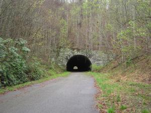
See photo.
or here
GSMNP landforms and campsites
and
trails (TN/NC)
 AT shelters
BSF landforms (TN/KY)
AT shelters
BSF landforms (TN/KY)
Tennessee landforms
home
arches
waterfalls
rocks
peaks
balds
sinkholes
lakes
regions
 ©
Tom Dunigan
©
Tom Dunigan