| WGS84 | |
| 35.562600 | -83.974500 |
| 35° 33.756'N | 83° 58.47'W |
| 35° 33' 45.4"N | 83° 58' 28.2"W |
| 17S 230403E 3939508N | |
| convert to NAD27 | |
MAPS
Select one of the following maps to display this waypoint (WGS84).
GPS
Remarks:
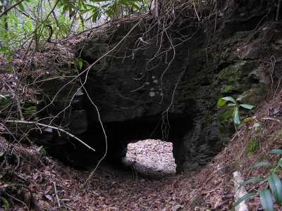
Small (man-made?) arch on edge of Panther Creek. Old cables indicate that it was used as an anchor point in years past. off-trail, remnants of old roadbed (logging & slate mining), see 1931 Park map Further upstream is Panther Creek falls
 AT shelters
BSF landforms (TN/KY)
AT shelters
BSF landforms (TN/KY)