| WGS84 | |
| 35.562400 | -83.800600 |
| 35° 33.744'N | 83° 48.036'W |
| 35° 33' 44.6"N | 83° 48' 2.2"W |
| 17S 246169E 3939024N | |
| convert to NAD27 | |
MAPS
Select one of the following maps to display this waypoint (WGS84).
GPS
Remarks:
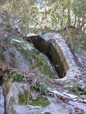
A gravity arch at the top of the 200'+ cascade. If you've visited the cascade and giant chestnut oak, you might see if you can find this arch. off-trail
 AT shelters
BSF landforms (TN/KY)
AT shelters
BSF landforms (TN/KY)