
| WGS84 | |
| 35.478300 | -83.741300 |
| 35° 28.698'N | 83° 44.478'W |
| 35° 28' 41.9"N | 83° 44' 28.7"W |
| 17S 251285E 3929542N | |
| convert to NAD27 | |
MAPS
Select one of the following maps to display this waypoint (WGS84).
GPS
Remarks:
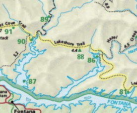
This is the new BC88, the older closed BC88 was on Pinnacle Creek which is no longer maintained. This site is on the new section of Lakeshore trail between 90 and 86 along Shehan Branch, 1.4 miles from junction with Hazel Creek trail. This site is not shown yet (2007) on park maps, but if it were, it would be about here:
Or select Lake Shore Trail on our Google map.
 AT shelters
BSF landforms (TN/KY)
AT shelters
BSF landforms (TN/KY)