Great Smoky Mountains National Park Campsites| WGS84 |
| 35.511100 | -83.399170 |
| 35° 30.666'N | 83° 23.95'W |
| 35° 30' 40"N | 83° 23' 57"W |
| 17S 282421E 3932371N |
| convert to NAD27 |
INDIAN CREEK BC46 
Waypoint: BC046 35.511100,-83.399170
Locale: Deep Creek IndianCreek
Elevation: 2680'
reservation and fee required
GSMNP camping info permits, fees, reservations etc.
popup list of
nearby landforms/campsites (mileage, bearing)
MAPS
Select one of the following maps to display this waypoint (WGS84).
GPS
Remarks:
New 2009, no horses. Check with Backcountry Office.
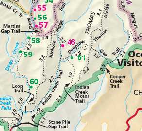 It will eventually appear on trail maps about here.
GSMNP landforms and campsites
and
trails (TN/NC)
 AT shelters
BSF landforms (TN/KY)
AT shelters
BSF landforms (TN/KY)
Tennessee landforms
home
arches
waterfalls
rocks
peaks
balds
sinkholes
lakes
regions
 ©
Tom Dunigan
©
Tom Dunigan